Cerro Electrico
We made it! Summit!

After being on the road for almost two months, we finally made our way to El Chaltén, Argentina. We have been looking tremendously forward to being here. It’s a true climber’s paradise. Here’s everything from grade IV sports climbing to some of the most challenging alpine climbing routes in the world and everything in between. We’re mostly aiming for some of those in between. Cerro Electrico is one of them.
The trailhead is located about 15 kilometers north of El Chaltén along a surprisingly busy gravel road. As life in El Chaltén is expensive enough to begin with, we decided to see if we could hitch a ride out of town towards the trailhead. At the edge of town, we found a suitable spot where we could try our luck. After less than 15 minutes, we managed to get a ride in the back of a silver pickup truck. There’s nothing quite like hitchhiking in the back of a pickup truck. The wind rushing through your hair and the dust covering you by the second. This is how adventure begins!

After about 40 minutes of bumping up and down in the back of the pickup, we made it to the trailhead. From here, we started our approach on foot towards Cerro Electrico. The first part of the trail follows a good and well-marked path, which is shared with multiple day hikes. After about an hour, the main path turns right, and a narrow climber’s trail continues straight. You have to know what you’re looking for, or you’ll likely miss it. The path, just wide enough for a mountain boot, winds its way cozily through the forest. As you progress through the forest, the incline gently increases until you reach the base of the gully. From here, the path begins to show its teeth. The first section through the gully is covered in low, dense bushes, making it a challenge to move forward, especially with big and broad backpacks. From time to time the path cuts through short rock sections, making it a fun and varied approach.

After about 4 hours, we made it to our planned campsite. On a plateau just under the glacier is an improvised campsite, which is used regularly by climbers. Calling it a campsite is maybe a bit of a stretch, but it’s a nice flat area which offers plenty of space and good protection from the Patagonian winds. We pitched our tent in a small clearing between low bushes and a solid stone wall. This was remarkably close to the perfect camp spot.
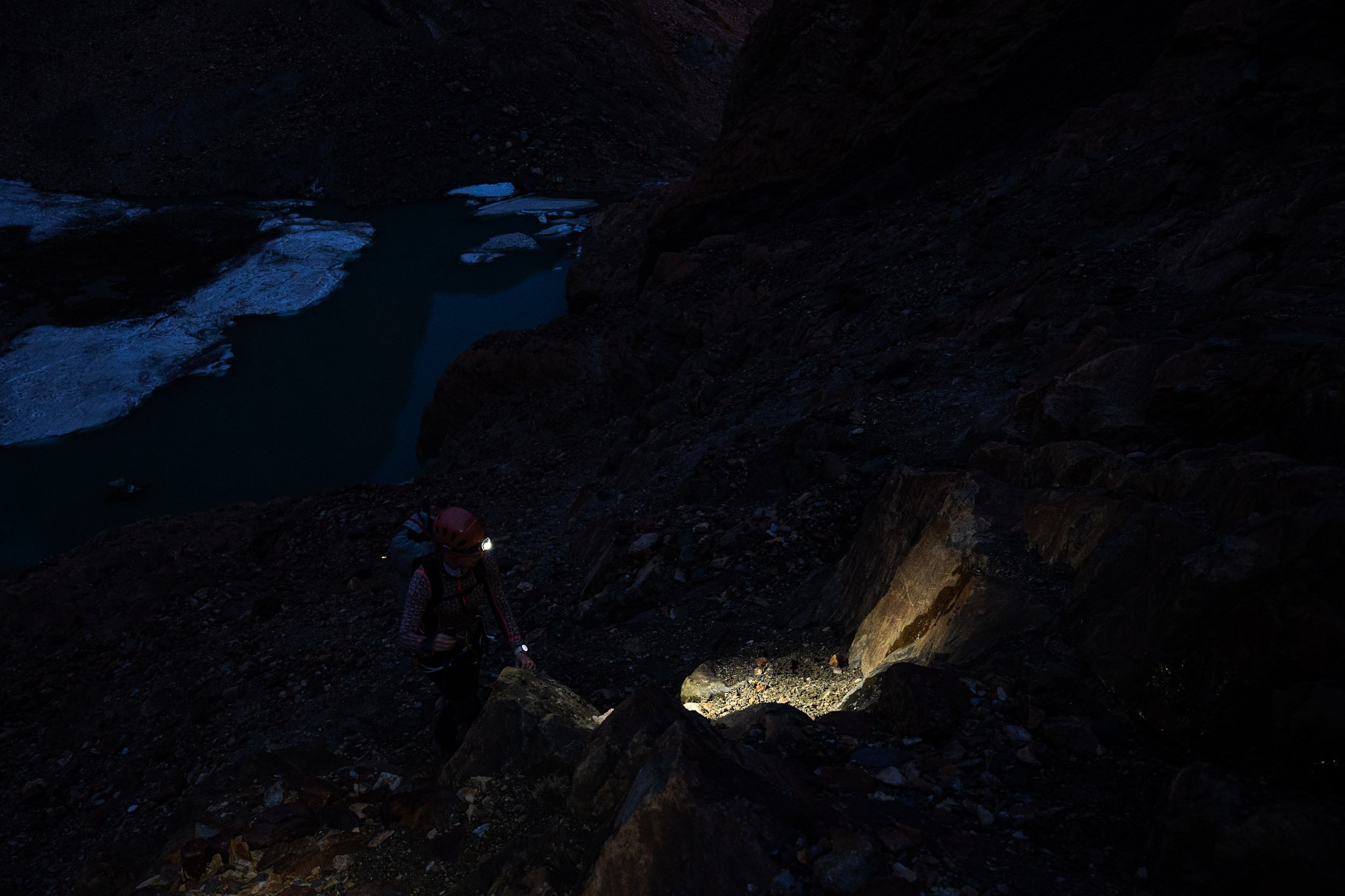
From articles and guide books, we knew that the route continued from the campsite towards a small glacier lake about half an hour further up the mountain. From here, you should be able to step onto the glacier and use that as your highway to the summit. After having enjoyed the afternoon sun for a bit, we decided to make our way towards the glacier lake. Our plan was to start the climb well before daybreak the next day. Navigating in the dark can be challenging, so preparing a bit by doing the first part of the route is always a good idea. That way, you help yourself to a good start in the morning.

From climbing in the Alps, we've unfortunately become accustomed to retreating glaciers. As a mountaineer, the effects of a changing climate are ever-present. Once majestic seas of ice have been reduced to a mere shadow of themselves. Standing at the glacier lake, we were frightened by what faced us. Not because of the technical nature of the climb, but by the fact that we were staring at a glacier hanging no less than a few hundred vertical meters above us. A truly devastating sight. After having taken in the sight, we turned into problem-solving mode. Stepping straight onto the glacier was clearly out of the question. We needed to find another way up. We knew that the summit is relatively frequently climbed, meaning that a way through the rocks must exist. After a quick scan to the right of the lake, that approach was excluded.
Online, we had read about an alternative approach leading through a gully further to the left of the glacier. After a quick glance, this was also excluded. Clearly that route had been climbed earlier in the season when there was still more snow in the gully. By now the gully had been transformed into a fast-flowing stream. Not a great way up…
This left one possible option: The immediate left side of the lake. From where we were standing, it wasn’t exactly looking like an obvious route, but we decided to get a closer look. As we approached the wall of rock and scree, a route began to form in front of us. The occasional stone man and disturbances in the dirt left by other climbers gave us the confidence that there was a way through.

The next morning, we woke early in order to take advantage of the cold temperatures on the mountain. When crossing snow and ice, it's best to do so before the sun warms it too much. As the temperature rises, the snow turns to slush ice, not dissimilar in texture to the sugary ice drink you give to kids of all ages. Walking in slush ice has two distinct disadvantages. Firstly, it’s physically exhausting, and secondly, the structural integrity is much worse than firm, consolidated snow.
After a quick breakfast, we headed out. We knew from our reconnaissance the day before that we had to make our way around the left side of the lake. Here, we would reach a point where we could start up the scree and rock. With the light of our headlamps, we started making our way up the mountain.
Navigating through the rock and scree progressed well, and as the sun rose, we were treated to an astonishing sunrise. After scrambling for about an hour, we made it to the first snowfield. With the snow cover, we couldn’t easily identify where the border between rock and ice was, so we decided to rope up. When making your way across a glacier, you want to be roped up in the event that you fall through the snow and into a crevasse. Without the rope, a potential crevasse rescue is drastically more challenging.

Unfortunately for us, the sky had been covered with clouds throughout the night, and the temperature never reached below zero degrees Celsius. This resulted in a top layer of very soft snow. The conditions on the glacier were not truly bad, but they were also not great. The soft snow made progress slow and unnecessarily hard. With every step we took, we fell through to your knees. When temperatures drop just below freezing during the night, the top layer of snow turns firm, making it much easier and faster to walk.

About halfway up the mountain, we were faced with two options: Keeping left and crossing a rather steep section of uncovered glacier, or making our way to the right side of the glacier and follow the snow along the ridge. Not fully convinced about crossing the exposed ice, we decided to first give the right side a try. About halfway over the glacier, we got stopped by a significant crevasse. There were clear signs of other climbers having crossed, but the poor snow conditions made it impossible to cross safely. We retraced our steps back to where we had turned off and began making our way up the left side of the glacier.
An important lesson that we have learned again and again on this trip is not to discount a route from a distance. When in doubt, get as close as you can and assess it from there. Crossing over the ice turned out to be just fine. We slowed down a bit to make sure that we could focus on every step, and after a few minutes, we had made it across.

Once we had crossed the ice, the last part of the route continued over the snow-covered glacier. Approaching the summit plateau, an unbelievable view of the Fitz Roy presents itself - A mountain that has been captivating the dreams of climbers for decades.

Finally, the summit! We made it to the summit plateau at 9 o’clock on January the 4th. We knew from our research that it is possible to climb the last few meters of rock from the summit plateau to the true summit. Unfortunately, the rock is of extraordinarily poor quality. It basically breaks of in your hands. Because of this, we decided that the summit plateau was summit enough for us. Happy that we had made it this far, we took a moment to celebrate with a sip of water and an Oreo cookie. After a few photos and a summit message sent home with our Garmin InReach, we began making our way down the mountain.

Going down is almost always faster and much less exhausting. This was luckily no exception. As the sun was now fully up, the temperature was beginning to rise. It was time to get off the ice before the snow got too soft to carry our weight across the crevasses. From what we could see while going up, we had at least 5 larger crevasses to cross before we were off the ice again. Back on solid ground, we cleaned up the rope and took a moment to enjoy the sun before we continued our way down.

Heading down through the final part required focus and attention. As the route is not clearly marked, it's easy to lose track and end up at a dead end. The section is not really technically difficult but somewhat exposed in a few places, making full focus a necessity.

Back at our campsite, we spent the rest of the day relaxing and enjoying the sun. Normally, we walk all the way down after a summit, but with the truly outstanding weather, we decided to stay another night.
After a good night's sleep, we packed up our belongings and continued down the mountain until we once again stood at the trailhead - One very successful adventure richer. The only challenge still standing was getting back to El Chaltén. We knew ahead of time that hitchhiking back to El Chaltén would be challenging early in the morning. At that time of day, most people drive out of town to the trailheads and only return late in the afternoon. After trying our luck for about an hour, a true businessman of a taxi driver stopped and offered us the return trip at a discounted rate. He was anyway going that way with an empty car. We took the deal and made our way back towards El Chaltén.


