Torres del Paine - The O-Circuit
After a few days of rest and some preparation, we were ready to set off for the O-Circuit around Torres del Paine National Park. Most visitors visit the park on day tours or hike a section of the O-Circuit called the W-Circuit. The routes are named after the shapes they form on the map: an “O” and a “W”.

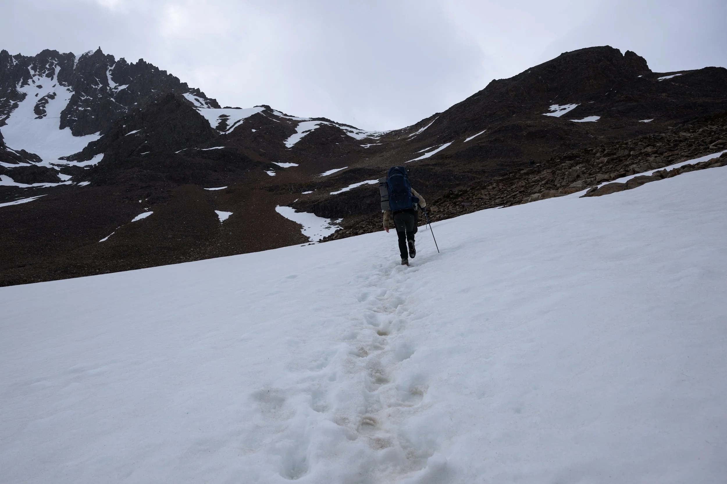
The route is generally speaking easy and poses no technical challenges. The pathfinding is also incredibly straightforward. During the entirety of the circuit you have to choose between paths a handful of times. All intersections are clearly marked and you will have to try hard if you want to get lost. From the moment you enter the park it’s apparent that the park is structured to handle a high volume of visitors. Many of whom have limited outdoor experience.

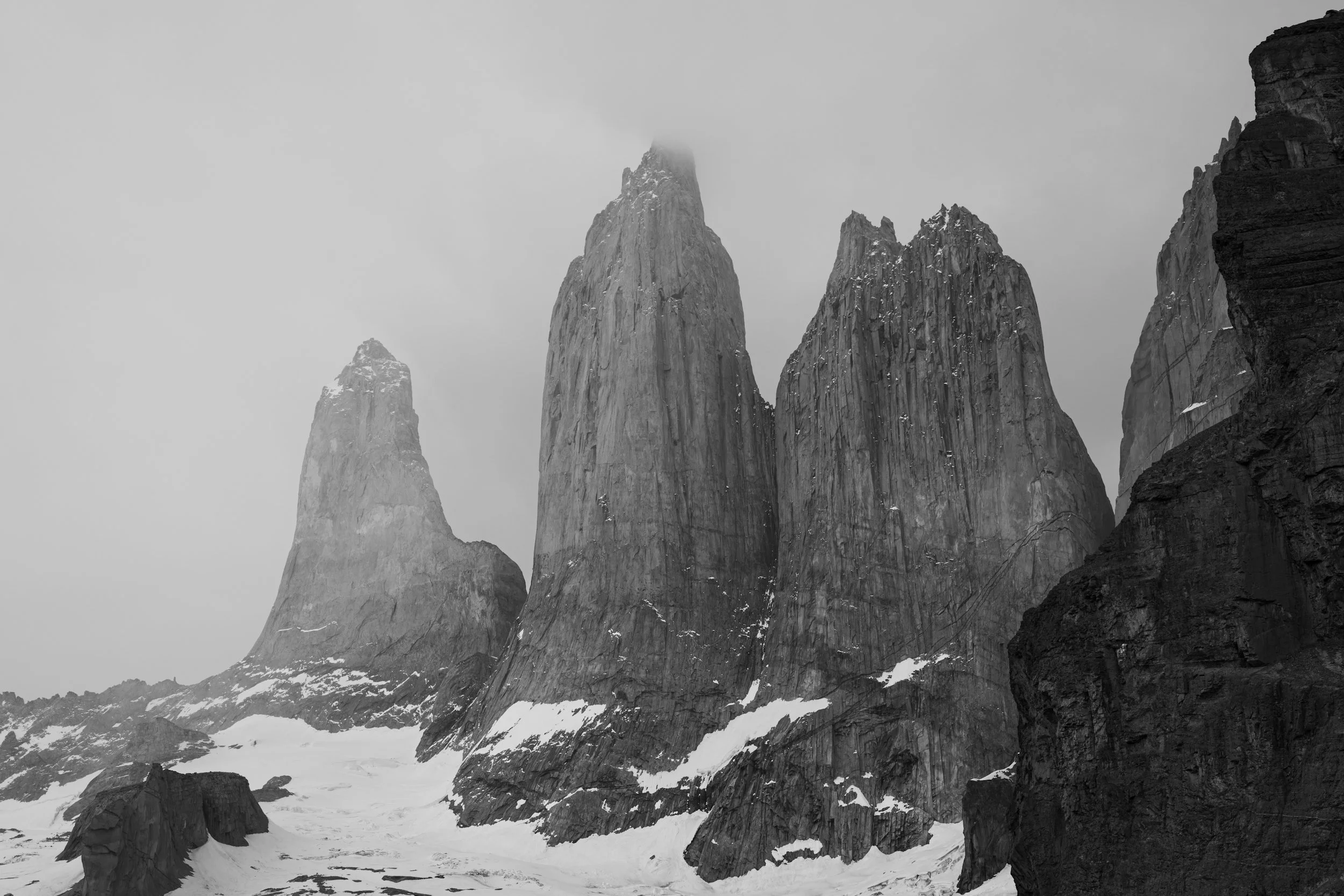
What the route lacks in technical challenges, it more than makes up for with breathtaking scenery. It is no wonder that this is one of the most sought-after hikes on the continent. Astonishing lakes, spectacular mountains and glaciers as you will only see them in a few places on earth. We were incredibly lucky with the weather - six days of near-perfect conditions. Considering Patagonia’s unpredictable weather, we had more luck than we could have dreamt of.

The first part of the route, from the park entrance to Grey, offers minimal flexibility in where to camp. After Grey you have a bit more flexibility and the choice between a few variations. Most hikers complete the circuit in about 8 days, we did it in 6. Mostly because we were too late with booking the campsites and therefore had to skip a few because they had no space left. This made for some long days at the end but it added to the adventure. This was our itinerary:
Day 1 - From the park entrance to Serón - 14,6 km (361/329 m ascent/descent)
Day 2 - From Serón to Dickson - 19,5 km (664/626 m ascent/descent)
Day 3 - From Dickson to Los Perros - 14,7 km (567/214 m ascent/descent)
Day 4 - From Los Perros to Grey - 18,1 km (1068/1560 m ascent/descent)
Day 5 - From Grey, via Valle Frances to Los Cuernos - 29,4 km (1237/1229 m ascent/descent)
Day 6 - From Los Cuernos, via Base Las Torres to the park entrance - 29,1 km (1663/1628 m ascent/descent)

Every campsite has some form of a common area where people can cook and eat. At night, the main topic of conversation was food choices: Mashed potato powder, cup noodles or freeze-dried meals. Forget politics: No talk about elections or wars raging on other continents. People talk with enthusiasm about the two fresh carrots that they brought for the first night's dinner and with regret about the six apples intended for breakfast in the coming days. Now they’re probably all gonna end up as snacks tomorrow in an attempt to bring down the overall weight of the backpack.

Since you don’t have much choice in where to sleep early on, you end up hiking with the same group for a few days. After a day or so you have familiarised yourself with all the faces and had a chance to talk with some of them. Some people are fast while others take their time and enjoy an afternoon nap in the shadow of a tree. You often end up leapfrogging each other on the trail. This time, we ended up hiking with a Danish couple for a few days. A doctor and a restaurant manager. A lovely couple with great stories. Conversation helps against the pain. When you keep your mind occupied, you forget the physical exertion. If you walk in silence, the battle becomes more mental than physical.
By day three, you can tell who is a seasoned hiker. The way people move around camp tells a crystal clear story. Sore muscles, aching joints and for the unlucky, a blister or two. All part of the experience.

As the days progress, a special bond begins to form between the people hiking the O-Circuit. A bond forged through the shared experience of the adversity endured. A bond not dissimilar to the one experienced in military units. The strong help the weak and the cheerful lifts the mood in dark moments. We are in this together. When the O-Circuit meets the W, the crowds can get overwhelming. There’s too many people for you to relate to them all. Once in a while you’ll pass by a fellow O-trekker and share an acknowledging nod we’re the real ones.

Most campsites have a “free” box where hikers can leave unwanted items. You’ll often find half-empty gas canisters. With a bit of luck you might also find some extra food. To keep the weight of our backpacks as low as possible, we had planned our food supply quite tightly so the joy was very real when we on day five found a box containing more than half a kilo of plain white rice. The additional calories were a pleasant surprise. And to make it even better, in another box we found a pack of delicious cashew and date snacks. Why anyone would abandon such a treat is a mystery, but we weren’t complaining.


For anyone embarking on this kind of an adventure, here’s a few tips that help make life a bit more enjoyable:
Pack calorie-dense foods. You will burn more calories than you think. Skip the carrots and apples. Priorities calories over vitamins.
Stay hydrated! Dehydration is a real risk. It happens more often than you think.
Know how to pitch your tent - also when you’re tired and it’s dark.
Also, know how to use your gas burner. It’s not cool being the one who has to look at the step-by-step guide; how to use my burner hanging in the common room.
When packing your bag: If you doubt whether to bring it, then it’s most likely not essential. A moka pot is not essential.
And finally, do your research. Understand the route and its challenges - and be honest with yourself. You’re not only endangering yourself but also the people around you if you’re not ready pfor the adventure you’re about to embark on.
Free bonus tip: Don’t forget to have fun. And if it’s not fun in the moment, it will probably turn into a great story in a few days.